Quality Control
The quality control program at SGL is designed to ensure
that every survey is planned and executed to obtain final
products of the highest quality possible. SGL
incorporates important control procedures into all parts
of the survey process.
Planning
Careful planning of the survey is an important step in
eliminating problems later in the project and in meeting
the project's objectives. The main points to be
considered in the planning stage are as follows:
-
Flight Specifications
Main specifications to be considered are:
- Line spacing (traverse and control lines),
- Line direction,
- Flight altitude or height above ground, and
- Tolerances for altitude and positional deviations.
Factors to be considered include:
- Will the survey, as specified, detect the
anticipated targets?
Forward modelling is a good method to evaluate
the amplitude and wavelength of the anticipated
anomalies at the proposed flight altitude. Line
spacing should be adequate to describe the field
at survey altitude, preferably with some
redundancy.
- Is it physically possible to fly the survey as
planned?
Steep topography, cultural features, continuous
cloud cover on hill tops can make it impossible to
fly a survey as specified. A change of the survey
specifications or the survey aircraft may be
required in such cases. (i.e., substituting a
helicopter for a fixed-wing aircraft)
- The adequacy of the proposed navigation system
to fly the lines as specified?
-
Equipment
The survey system and individual instruments must be
selected to conform to noise standards, under
realistic survey conditions. The data acquisition
rates should be adequate to depict the anticipated
frequencies preferably with some redundancy. The SGL
SGDAS computer based data acquisition system
allows flexible data recording rates. Data from
different systems can be recorded at different rates,
up to over a hundred readings per second. Each
reading is provided with its own time stamp with a
resolution of 1/120 of a second.
With the increased number of computers in the survey
aircraft, data acquisition and instrument control
software is now a major part of the survey system.
Before the start of a project, it is important to
ensure that both the software and hardware to be used
are appropriate for the job, are in working condition,
and have been thoroughly tested and de-bugged.
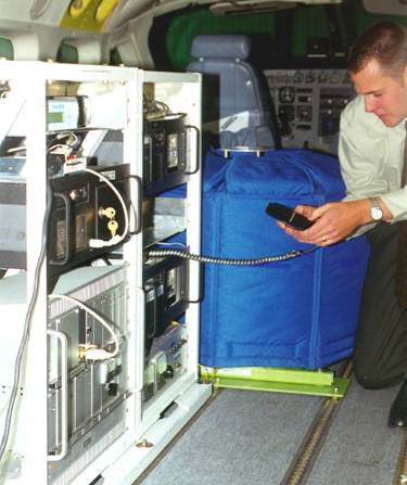
Equipment rack as installed
in aircraft
-
Aircraft
The type of survey aircraft chosen should ensure that
it is possible to fly the survey as specified, in an
efficient and safe manner. Important considerations
are:
- Rate of climb of the aircraft in survey mode
- Endurance in survey mode
- Aircraft to ground communications. These allow
the ground crew to monitor the progress of the
aircraft, inform the air crew of diurnal conditions,
and to answer technical questions that might arise,
during a flight. The radio link should operate
without disturbing the survey instruments.
- Aircraft maintenance facilities and spare parts
supplies, for timely aircraft maintenance
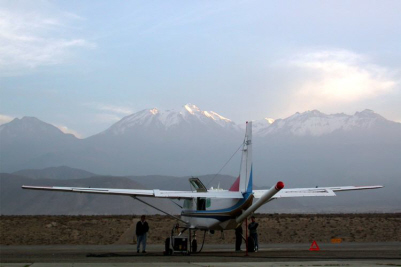
Survey aircraft in Peru
-
Field Crew
A well educated, experienced and conscientious field
crew is the most important aspect of quality control.
Field Operations
-
Project Management
During the field operation, each flight is planned to
maximize data quality, and safety. Considerations for
the quality of data include:
- Number and geometry of satellites for GPS
positioning
- Diurnal changes in the magnetic field for a
magnetometer survey
- Air turbulence in the survey area at the flight
altitude
- Clouds which might prevent flying lines as planned
- Radio transmissions which may be required
- Other signals which might interfere with the
geophysical instruments such as radar, microwave and
radio or television transmissions
-
In-Flight
SGL´s survey aircraft are crewed by two qualified
pilots. During take-off and landing, both can
concentrate on the pilot's duties, but during the
survey operations, one crew member takes
responsibility for the aircraft, while the other
operates and monitors the geophysical and navigation
equipment. Operation of the geophysical equipment is
essentially automatic: the operator enters the number
and direction of the line to be flown. All other
functions are computer-controlled.
The instrument performance is monitored on a video
screen, which displays analog traces of all data
streams and differences of selected data in real-time.
SGL's navigation program, SGNav
calculates the start and end points of each line in
the survey area and guides the pilot to the start of a
line. Once on the line, an analog needle shows the
cross track position. A digital readout on the
instrument panel displays the distance to the end of
the line. The GPS altitude, and barometric and radar
altimeters are used to monitor the flight altitude.
UTC time synchronization to the nearest millisecond
is provided automatically from the GPS receiver.
-
Post-Flight
Immediately after each flight, data are transferred
from the aircraft and copied onto a computer in the
field office.
The following quality control procedures are
completed within 24 hours of the end of each flight:
- Copying of data for safe storage and transfer to
the head office,
- SGL's visualization software generates data
profiles directly from the acquired data files,
producing an image of the data exactly as recorded,
and allowing the data to be examined interactively,
- Post-processed differentially corrected GPS data
are used to produce flight path images for review,
- Checking for data quality and completeness, with
the help of appropriate computer programs, and
- Reviewing of the records by the field operations
manager.
Digital flight path video are reviewed during field
operations, to check the functioning of the digital
video recorder. Preliminary colour maps and data
profiles are produced in the field, as a test of
general data quality.
-
Ground Stations
- MAGNETOMETER GROUND STATION
Location: Ground station magnetometer
sensors should be located away from high magnetic
gradients, large metallic objects, moving
vehicles, power lines, and radio frequency
transmitters and at a location where the field
crew can easily check for magnetic storms.
Operation: SGL´s ground station
magnetometers are micro-computer based. Data are
recorded on a hard disk, which can accommodate
months of data under normal circumstances. Time
intervals to record are programmable, reducing the
chance for missing data. Time synchronization is
provided by GPS. The accuracy of the recorded
time is better than one millisecond.
Checking: The ground station magnetometer
profiles are plotted on an analog record for easy
correlation of the data sets.
- GPS GROUND STATION
Location: The GPS antenna should have a
clear view of the sky in all directions; trees,
power lines and towers will interfere with the GPS
signals.
Checking: Profiles of the recorded
altitude, latitude and longitude, and the recorded
satellite ranges, enable the field crew to ensure
that the GPS ground station is working properly.
-
Transportation of Data
The best protection for the data during
transportation is to have multiple copies of the data
at different locations. SGL's PC based system allows
the field crew to make copies quickly and easily,
immediately after each flight.
Data Compilation
As in the field operations, quality control is an
integral part of the data compilation procedure. The
following are some of the main methods used:
- Checking of data for completeness, conformity with
specifications, or unusual conditions, immediately upon
receipt in the office,
- Plotting profiles of the data at various stages during
the compilation procedure,
- Listings of error situations are investigated by the
geophysicist in charge, and
- Listing, and plotting in graphical form levelling
adjustments for magnetometer data.
Data Deliveries
Before delivery all final data are checked to ensure that
the correct data have been included, that they are
readable and complete. Data formats and media should be
described in detail in digital documentation accompanying
the delivery.
Project Report
The final report should give a complete description of
the project area, survey parameters, aircraft and
equipment used, data processing parameters, as well as a
listing of the final products and the delivered digital
data.
|