-
SERVICES
- Gravity » AIRGrav
- Marine AIRGrav
- Magnetic Total Field
- Magnetic Gradient
- Radiometrics
- Frequency-Domain EM
- Geoid Applications with AIRGrav
- Scanning LiDAR
- Methane Sensing
- Multi-Parameter Surveys
- Environmental Monitoring
- Baseline Monitoring & Contamination Detection
- Data Interpretation
- Navigation » SGNav
- Drape Flying » SGDrape
- Quality Control
 |
|---|
 |
 Marine AIRGravSander Geophysics Limited (SGL) offers marine gravity surveys using SGL's Airborne Inertially Referenced Gravimeter (AIRGrav), adapted for marine use - called Marine AIRGrav. AIRGrav was designed and built by SGL for airborne surveys but can be used in any moving platform. Its ability to operate in the challenging airborne environment makes it ideally suited for marine application, where it can be used in conjunction with a marine seismic survey or as a standalone gravity survey. AIRGrav is over-engineered for marine surveys, where vibration and vessel acceleration is much lower than in an aircraft, resulting in better gravity data than can be obtained using traditional marine gravimeters. 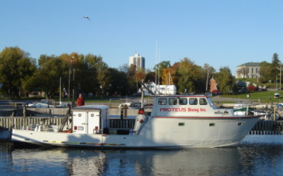 AIRGrav is the only purpose-built airborne gravimeter, designed specifically for the unique characteristics of the airborne environment and was easily adapted for use on a marine platform. This design approach has resulted in a superior gravity instrument which can be used twenty-four hours a day, even in challenging sea conditions. In addition, Marine AIRGrav can easily be used in combination with magnetic and/or sonar instruments to increase the survey benefits. Marine AIRGrav is an alternative to an airborne gravity survey in areas where an aircraft cannot fly (very far from land or in restricted flight areas) or for acquiring very high resolution data. Along with marine gravity data, Sander Geophysics can also acquire magnetic data with a towed magnetometer sensor, and measure bathymetry and shallow seabed structure with a side-scan sonar, or sub-bottom profiler. Marine AIRGrav can be also be used alongside a marine seismic system. Because of the low vessel speed of marine surveys, very high resolution gravimetric, magnetic and bathymetric data can be acquired. 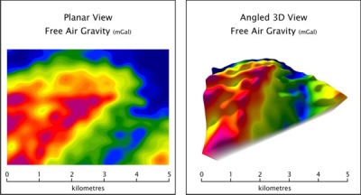 The Marine AIRGrav system includes a gravimeter on a three-axis inertially stabilized platform, combined with high resolution differential GPS to correct for vessel accelerations due to waves, changes in speed, turns, tides and currents. The gyro stabilized inertial platform makes the gravimeter much less affected by horizontal accelerations than other systems. Bathymetric and terrain corrections are performed using either existing digital bathymetry and terrain models or data acquired during the gravimetric survey. Digital bathymetric models can be supplemented with remote sensing data, depending on the nature of the sea floor and the resolution of the survey. A sonar sensor can gather high quality bathymetric data concurrently with the gravimetric survey. 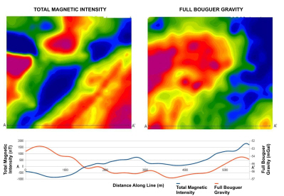 To demonstrate the capability of Marine AIRGrav, Sander Geophysics performed a marine gravity survey on Lake Ontario in October, 2009. The map above shows the terrain corrected Bouguer gravity and the total magnetic intensity, as well as a profile across the area. The data set consists of 200 m spaced lines along a bearing of 45°/225°, with control lines bearing 135°/315°. The extent of the data set is 5 km from north to south. During the test survey the waves were 1-1.5 m and very choppy, with a 10-20 kt (18.5-37.0 km/h) wind. Sailing speed was 8 kt (14.8 km/h). Accuracy was calculated to be 0.12 mGal with a 300 m resolution. Marine AIRGrav Survey System Specifications
|