-
SERVICES
- Gravity » AIRGrav
- Marine AIRGrav
- Magnetic Total Field
- Magnetic Gradient
- Radiometrics
- Frequency-Domain EM
- Geoid Applications with AIRGrav
- Scanning LiDAR
- Methane Sensing
- Multi-Parameter Surveys
- Environmental Monitoring
- Baseline Monitoring & Contamination Detection
- Data Interpretation
- Navigation » SGNav
- Drape Flying » SGDrape
- Quality Control
 |
|---|
 |
 Airborne Methane SensingSander Geophysics Limited (SGL) offers direct detection of hydrocarbon gases that naturally seep into the air. These gases can be related to active hydrocarbon systems, industrial activity, biogenic processes and landfills. Methane surveys conducted by SGL have shown that methane concentrations related to hydrocarbon systems are well above background levels, even in jungle environments. SGL uses ultra sensitive high resolution sensors mounted in a survey aircraft to record methane gas concentrations in the air. These airborne data can then be used to map ground level gas flux rates, matching measured data to known methane sources and potential hydrocarbon seeps. Airborne Methane Sensing Surveys at SGLSGL conducts methane surveys for petroleum exploration and environmental mapping. Intake air is collected by an inlet port mounted externally on the survey aircraft and is pumped through a particle separator filter to an off-axis integrated cavity output spectroscopy (OA-ICOS) analyzer recording at up to 20 Hz. Other geophysical information, such as gravity or magnetic data, can be collected simultaneously using SGL´s fixed-wing and helicopter platforms, thereby increasing the survey benefits. The position recovery uses NovAtel multi-frequency GNS (GPS) receivers in the aircraft and on the ground, processed using SGL´s proprietary GPSoft navigation processing system, resulting in a horizontal position accuracy of better than 0.2 m and a vertical position accuracy of better than 0.3 m. Proprietary processing is used to calculate the equivalent ground flux rate from the measured airborne data. Working with Shell Global Solution B.V., SGL has successfully measured methane gas flux over varied terrain including arid regions and jungle. 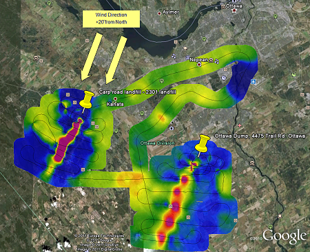
Measured hydrocarbon concentration above known methane sources Methane Sensing Survey System
Instruments for Simultaneous Multidisciplinary Surveys
|
|||||||||||||||||||||||||||||||||||||||||||||||||||||||||||||||||||||||||||||||||||||||||||||||||||