High Resolution
Magnetic Gradiometer Surveys
Sander Geophysics offers low level magnetic gradiometer
surveys of very high resolution and accuracy. The
gradiometers use two cesium magnetometers with a fixed
separation to measure the earth's vertical and/or
horizontal magnetic gradient. Total magnetic field
measurements are recorded simultaneously.
The vertical magnetic gradient offers a better means of
detecting near surface magnetic sources than total
magnetic field measurements, making the gradient method
ideal for mineral prospecting. Gradiometer surveying can
obtain exceptionally detailed data by flying at low
altitudes and moderate speeds.
Horizontal gradients provide detailed near-surface
information, and help to interpolate between survey flight
lines. This is especially important if the survey target
has similar dimensions to the survey line spacing. Both
gradients are much less affected by diurnal changes in the
magnetic field so they are ideal for use in areas where
significant diurnal activity are expected.
We use optically-pumped cesium magnetometers with a
sensitivity of 0.005 nT, and real-time digital
compensation, giving an overall system resolution of 0.01
nT. The magnetometers in the aircraft and in the ground
station are identical, ensuring that all magnetometer data
sets are equivalent in terms of sensitivity and noise
envelope. The sampling rate can be adjusted from 2 to 10
Hz depending on survey specifications.
Cesium magnetometers are ideally suited for gradiometer
surveying because of their very high resolution and
exceptional stability. Flight direction changes do not
require reorientation of the magnetometer sensors.
Good navigation and accurate flight path recovery are
very important considerations for high resolution airborne
gradiometer surveying. Our aircraft are equipped with
Global Positioning System (GPS) integrated into a
proprietary navigation and flight path recovery system.
This system, called SGNav, allows for excellent
navigation providing an accuracy of better than 1 m in
post-flight recovery.
Sander Geophysics is well equipped to provide data
processing, a variety of map presentations and
interpretation services to enhance the usefulness of its
vertical gradient surveys.
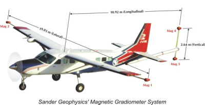
Magnetic Gradiometer Survey System
| Airborne Instruments |
| Magnetometer Sensor |
Geometrics |
| Strap-down, optically pumped, cesium
split beam |
| Sensitivity: 0.005 nT |
| Sensor noise level: <0.02 nT |
| Sampling rate: 10 Hz |
| Sensor Separation |
Helicopter: 3 m vertical |
| Fixed-wing: 2.64 m vertical, 19 m
horizontal |
| Gradient Noise Level |
Less than 0.02 nT/m vertical |
| Less than 0.005 nT/m horizontal |
| Compensator |
Sander Geophysics - AIRComp
real-time digital compensation |
| Range: 20,000 to 200,000 nT |
| Resolution: 0.001 nT |
| Sampling rate: 160 Hz |
| Data Acquisition System |
Sander Geophysics - SGDAS
airborne computer |
| Capable of recording unlimited number
of channels at variable intervals, and digital
scrolling chart display of the data. Data is
recorded on a vibration tolerant removable drive.
The system clock is a quartz time standard
automatically synchronizsed to UTC by the GPS signal
to an accuracy of 1 millisecond. |
| Video Imaging System |
Sander Geophysics - SGDIS
digital video |
| Radar Altimeter |
|
Resolution (m) |
Calibrated to |
Range
(m) |
| TRT AHV8 |
0.5 |
1% |
0 to 3,050 (10,000 ft) |
| King KRA-10 |
0.1 |
1% |
0 to 760 (2,500 ft) |
| FreeFlight |
0.5 |
1% |
0 to 760 (2,500 ft) |
| Barometric Altimeter |
Sander Geophysics Digitally Recording
Barometric Altimeter |
2.0 |
±4 m |
0 to 10,000 (30,000 ft) |
| Ground Station Instruments |
| Magnetometer Sensor |
Same as airborne |
| Magnetometer Interface |
Sander Geophysics - SGRef |
| Range: 20,000 to 100,000 nT |
| Resolution: 0.01 nT |
| Sampling rate: 2 Hz |
| Data Acquisition System |
Sander Geophysics - SGRef |
| This system runs SGL data acquisition
software capable of recording an unlimited number of
channels at variable intervals, and includes a
digital scrolling chart display of the data. Data
is recorded on a vibration tolerant removable drive.
The system clock is a quartz time standard
automatically synchronised to UTC by the GPS signal
to an accuracy of 1 millisecond. |
| Power Source |
12 VDC can be wind or solar powered |
| Navigation Instruments |
| Global Positioning System |
NovAtel 24-channel, dual frequency,
GPS receiver, (ground & airborne) |
| Sampling rate: 1 to 10 Hz |
| Real-Time Differential GPS (if
required) |
Satellite link (OmniStar or LandSTAR)
to the aircraft for real-time in-flight differential
GPS (RDGPS) |
|