Radiometric Surveys for
Baseline Monitoring & Contamination Detection
With over 40 years of gamma radiation survey experience,
Sander Geophysics Limited (SGL) has performed numerous
specialized radiometric surveys to assess radiation due to
man-made and natural sources. These surveys have
included:
- helicopter and fixed-wing airborne baseline surveys of
nuclear power plants and the surrounding urban areas;
- airborne baseline surveys of military establishments
including nuclear submarine bases;
- airborne and ground vehicle baseline surveys of
industrial and residential sites;
- ground based surveys to locate and identify
radioactive particles at nuclear sites;
- ground based survey to locate a lost borehole logging
cesium source; and,
- airborne surveys to determine snow depth for seasonal
water volume planning.
SGL specializes in delivering a turnkey solution to our
clients, and has been involved in all aspects of the
projects: from survey design and survey platform
modifications, data acquisition and processing to final
reports, including digital data, map products,
interpretation and recommendations for remediation and/or
followup.
Following are case studies of two projects completed by
SGL:
Case Study 1: Contamination Detection Survey
The transfer of radioactively contaminated material from
controlled zones within a nuclear facility to other areas
within or outside the facility may occur due to the
movement of vehicles, equipment and personnel. Accurate
detection and identification of any radioactive particles
outside the controlled zones is critical to ensure the
integrity and safety of operations of the installation.
Sander Geophysics, in partnership with international
radiation specialist Dr. Robert Grasty (Gamma-Bob Inc.),
conducted a ground survey at an active nuclear facility,
using a gamma-ray spectrometer equipped with large volume
sodium iodide (NaI) detectors mounted on a small tractor.
The purpose of the survey was to detect possible sources
of radioactive contamination, principally cesium-137 (137Cs)
and cobalt-60 (60Co), and to compare the
results to a similar survey carried out by SGL at the same
site 11 years earlier.
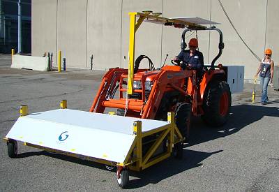
Ground survey of a nuclear
facility to locate and identify contaminated particles
The spectrometer system, manufactured by Radiation
Solutions Inc. (RSI), consisted of 16 NaI detectors
contained in four packs, with a total volume of 67 litres
(4,096 in3). Each of the 16 NaI detectors has
its own 1024 channel analyser, with the data from each
detector recorded separately at 1 Hz. Natural and
man-made sources of radiation were monitored using
spectral windows covering specific gamma-ray energies. A
Global Positioning System (GPS) coupled with an Inertial
Navigation System (INS) provided accurate location
information for the spectrometer data. The INS was
required as the survey was carried out close to large
buildings which obscured the GPS signal.
Surveying was conducted both inside and outside the
Protected Area of the site, covering a total area of
approximately 150,000 m2. Several sources of 60Co
contamination were detected inside the Protected Area.
Based on an analysis of particles found during the
survey, the detection limits for the system were found to
be 12 nCi for 60Co and 17 nCi for 137Cs.
The sources found in the gravel were as much as 2.5 cm
below the surface with little or no beta radiation being
detected at ground level. All sources found in the gravel
or asphalt were retrieved, contained and then passed to
the facility radiation personnel. A follow-up survey
showed that all localized sources of contamination had
been removed. Based on the survey, recommendations were
made for a long-term monitoring program of the site.
Maps were produced of the total air kerma rate and the
potassium-40 (40K), uranium-238 (238U)
and thorium-232 (232Th) activities of the site
and showed differences in the natural radioactivity levels
of roads and gravel areas. The overall radiation levels
were low, ranging from around 15 nGy.h-1 on
some of the paved roads to around 30 nGy.h-1 on
gravel areas. These low values are consistent with the
results from an earlier airborne gamma-ray survey of the
site.
Case Study 2: Baseline Radiation Monitoring Survey
Accurate radiological characterization is relevant to all
major phases of the lifetime of a nuclear facility,
including background surveys prior to commissioning and
after decommissioning, and site surveys at regular
intervals during the operational phase as well as
following any incident of possible contamination.
Baseline radiation data provides background information
for normal levels of radiation in the environment, and is
useful as a benchmark if a radiological emergency occurs
or to demonstrate that no significant changes have taken
place over the lifetime of a nuclear facility. Airborne
gamma spectrometry is an efficient method to rapidly
survey the environs of nuclear facilities, and the
airborne measurements can be converted to ground
concentrations to complement any ground based
measurements.
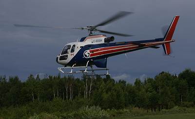
Baseline radiation survey using
a helicopter
Sander Geophysics conducted a baseline radiation survey
over the primary zones of a nuclear generating facility,
using a gamma-ray spectrometer system mounted in a
helicopter. In addition to identifying the distribution
of natural and man-made gamma emitting isotopes, the data
provided a gamma-ray baseline of the nuclear site and the
surrounding community. Similar surveys flown at a later
date, ideally at regular intervals, can then be used to
demonstrate that no significant changes have occurred.
Also, in the event of an accidental release of radiation
from the facility, a subsequent survey could then be used
to determine any increase in potential exposure for the
public.
For this survey, the spectrometer recorded 256 channels
of spectral information every second. The windows used to
monitor natural and man-made radiation sources were
centered around:
| a total count window used to monitor
overall levels of radioactivity |
| 40K gamma-rays at 1460 keV |
| 1760 keV gamma-rays from bismuth-214
(214Bi) in the 238U series |
| 2615 keV gamma-rays from thallium-208
(208Tl) in the 232Th series |
| 137Cs at 662 keV and 60Co
at 1173 keV |
| man-made radiation due to 41Ar
at 1294 keV between the upper boundary of the 60Co
window and the lower boundary of the K window |
| high energy gamma radiation at 6129
and 7115 keV from 16N by recording all
energies above 3 MeV and monitoring cosmic ray
changes |
Maps were produced of the potassium, uranium and thorium
radioactivity of the ground and of the total radiation
levels in units of air kerma rate (nGy.h-1) due
to all sources of gamma radiation. The natural radiation
levels of the survey area varied between 20 and 50 nGy.h-1
and are comparable to the values reported in government
data for the area.
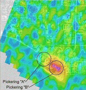
Airborne survey showing 16N
over active and inactive cooling towers at a nuclear
power station (PNGS)
Maps of the equivalent surface distribution of man-made
cesium-137 (137Cs), the equivalent activity of
cobalt-60 (60Co) and the count rates from
nitrogen-16 (16N) were produced. Although
argon-41 (41Ar) is produced through normal
operations, none was detected, and therefore, no maps of
this isotope were produced. Within the plant boundaries,
16N was detected directly over the operating
units, and is due to normal operations. At several
locations within the boundary of one of the facilities 137Cs
and 60Co were detected. The origin of this
radiation was storage facilities for spent fuel and
contaminated maintenance tools, and the operator was aware
of this man-made radiation before the survey was
conducted.
|